Sentinel-1 C-band SAR Constellation — From Mission Design to Real-World Applications
From ERS-1 to Sentinel-1, ESA’s C-band SAR programme has sustained over three decades of same-band Earth observation, producing the longest continuous microwave archive of its kind. This article systematically reviews Sentinel-1’s mission design rationale and technical evolution, elaborates its tiered product architecture, and discusses representative applications in InSAR deformation monitoring, marine remote sensing, and emergency response.
Note: This blog post was generated with AI assistance. Content is for reference only—please consult official sources for authoritative information.
1. Mission context
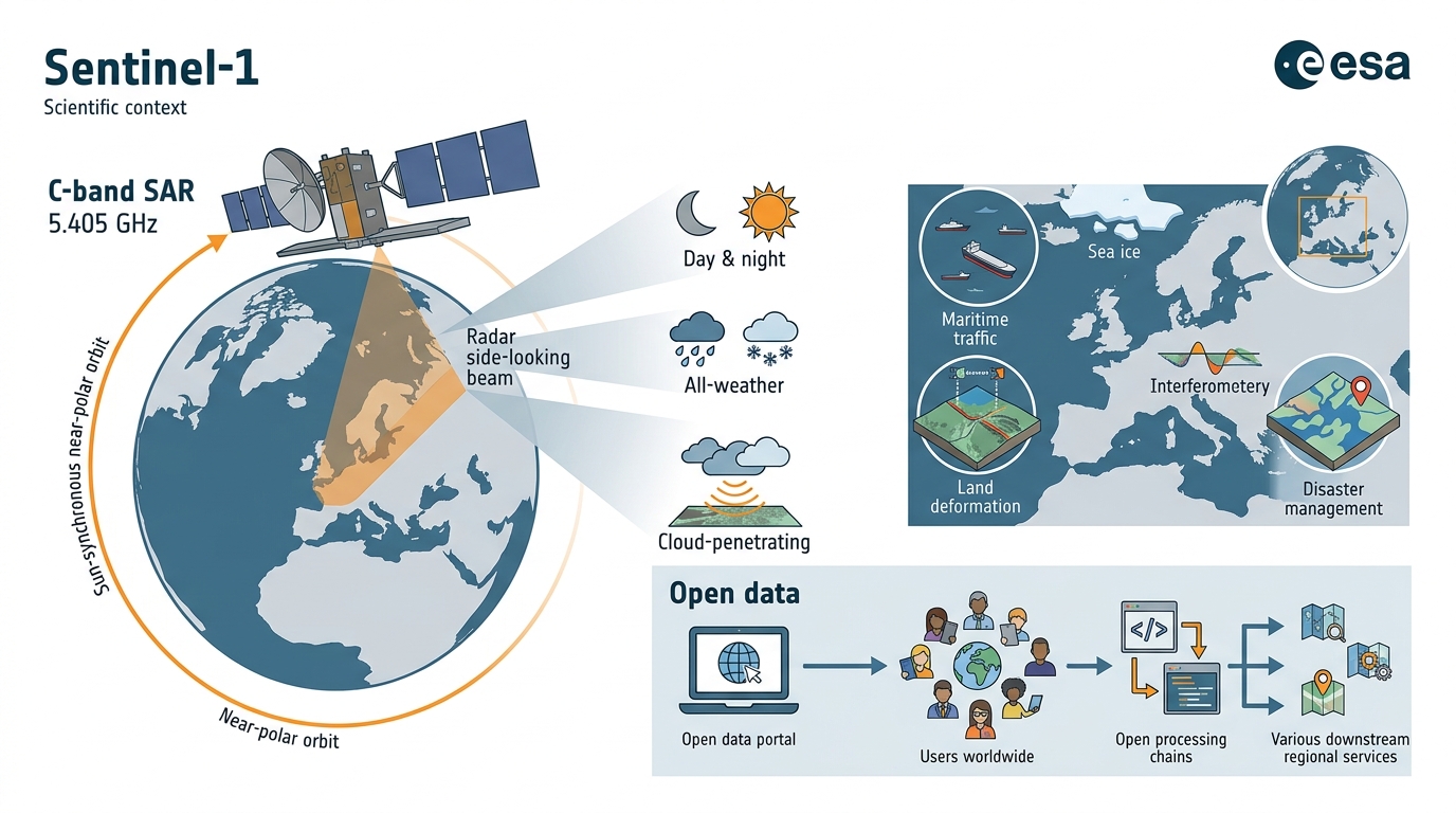
Sentinel-1 is ESA’s C-band synthetic aperture radar (SAR) constellation within the Copernicus Programme, designed for operational microwave Earth observation across Europe. C-band active microwave sensing supports day-and-night, all-weather acquisition with cloud-penetrating capability, making it well suited to long-term operational monitoring.
Its open data policy is an equally important dimension of the mission: Sentinel-1 products have been freely available worldwide since mission inception, providing the data foundation upon which open processing chains and regional downstream services have subsequently been built.
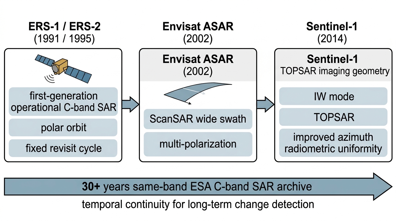
2. Technical lineage: ERS → Envisat → Sentinel-1
Sentinel-1 extends the technical line established by ESA’s two earlier C-band SAR missions:
- ERS-1 / ERS-2 (1991 / 1995) — first-generation operational C-band SAR, establishing the foundational observation framework of polar orbit and fixed revisit cycle
- Envisat ASAR (2002) — introduced ScanSAR wide-swath mode and multi-polarization capability, expanding adaptability across observation scenarios
- Sentinel-1 (2014) — IW mode adopts the TOPSAR scheme, significantly improving azimuth radiometric uniformity while maintaining wide swath coverage
The principal value of this lineage lies in temporal continuity: from ERS to Sentinel-1, ESA has maintained a same-band archive spanning more than three decades, providing a consistent data basis for long-term change detection and multi-epoch comparative analysis.
3. System configuration and acquisition modes
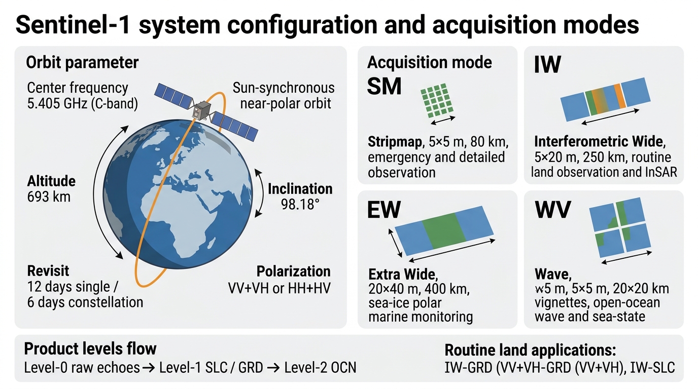
Orbit parameters
| Parameter | Value / configuration |
|---|---|
| Center frequency | 5.405 GHz (C-band) |
| Orbit type | Sun-synchronous, near-polar orbit |
| Orbit altitude | 693 km |
| Inclination | 98.18° |
| Revisit | 12 days for a single satellite, 6 days for the two-satellite constellation |
| Polarization | VV+VH or HH+HV |
Acquisition modes
| Mode | Resolution (Rg × Az) | Swath | Primary use |
|---|---|---|---|
| SM (Stripmap) | 5 × 5 m | 80 km | Emergency response and small-area detailed observation |
| IW (Interferometric Wide) | 5 × 20 m | 250 km | Routine land observation and InSAR analysis |
| EW (Extra Wide) | 20 × 40 m | 400 km | Sea-ice, polar, and large-area marine monitoring |
| WV (Wave) | 5 × 5 m | 20 × 20 km vignettes | Open-ocean wave and sea-state observation |
Product levels span Level-0 (raw echoes), Level-1 (SLC for interferometric measurement; GRD for intensity analysis), and Level-2 (OCN ocean retrievals). Routine land applications rely predominantly on IW-GRD (VV+VH) and IW-SLC.
4. Mission evolution
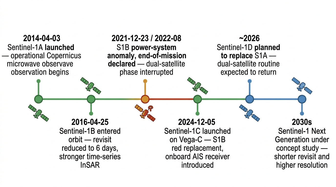
| Date | Event | Operational implication |
|---|---|---|
| 2014-04-03 | Sentinel-1A launched on Soyuz from Kourou | Operational Copernicus microwave observation formally began |
| 2016-04-25 | Sentinel-1B entered orbit | Constellation revisit reduced to 6 days; time-series InSAR capability was substantially enhanced |
| 2021-12-23 / 2022-08 | S1B experienced a power-system anomaly and ESA later declared end-of-mission | The dual-satellite 6-day revisit phase was interrupted |
| 2024-12-05 | Sentinel-1C launched on Vega-C | S1B replacement entered service and an onboard AIS receiver was introduced for the first time |
| ~2026 | Sentinel-1D is planned to replace S1A | Routine dual-satellite operation is expected to be restored |
| 2030s | Sentinel-1 Next Generation (NG) remains under concept study | Principal targets include shorter revisit intervals and higher spatial resolution |
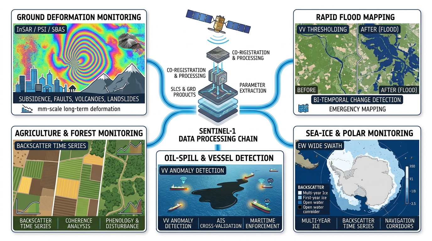
5. Representative application pathways
Along the technical chain from constellation acquisition through data processing to downstream analysis, representative Sentinel-1 applications can be summarised in terms of method, target, and use:
- Ground deformation monitoring — Method: InSAR / PSI / SBAS. Target: subsiding cities, active faults, volcanoes, and landslides. Use: millimetre-scale annual deformation rate retrieval, long time-series analysis, and regional product generation (e.g. EGMS).
- Rapid flood mapping — Method: VV thresholding and bi-temporal change detection. Target: floodplains, urban inundation zones, and river overbank areas. Use: post-event water extent extraction, emergency assessment, and rapid mapping.
- Sea-ice and polar monitoring — Method: EW wide-swath acquisition and time-series backscatter interpretation. Target: sea-ice extent, marginal ice zones, and polar navigation corridors. Use: sea-ice dynamics monitoring, route assessment, and regional situational analysis.
- Oil-spill and vessel detection — Method: VV-based anomaly detection with AIS cross-validation. Target: oil slicks, vessel targets, and coastal traffic corridors. Use: marine pollution monitoring, vessel activity identification, and maritime enforcement support.
- Agriculture and forest monitoring — Method: backscatter time-series analysis and coherence analysis. Target: cropland parcels, forested areas, and suspected deforestation zones. Use: phenology mapping, land-cover change monitoring, and forest disturbance assessment.
6. Data access
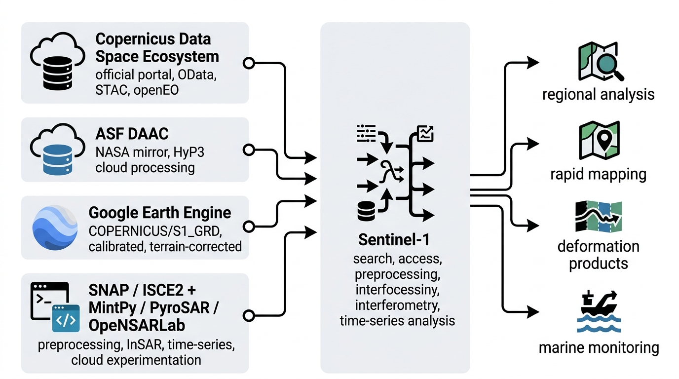
| Source / tool | Role | Access or processing characteristics |
|---|---|---|
| Copernicus Data Space Ecosystem | Official data portal and successor to SciHub | Supports OData, STAC, and openEO; suitable for mission-level search and bulk access |
| ASF DAAC | NASA mirror and distribution entry point | Commonly used by North American users and provides HyP3 cloud processing |
| Google Earth Engine | Online analysis platform | COPERNICUS/S1_GRD is radiometrically calibrated and terrain-corrected, supporting rapid time-series and regional analysis |
| SNAP / ISCE2 + MintPy / PyroSAR / OpenSARLab | Common processing toolchain | Covers Sentinel-1 preprocessing, interferometric workflows, time-series analysis, and cloud-based experimentation |